
At Monday's city commission meeting, commissioners considered an Application #M23-9, filed by the Salina City Planning Commission, requesting an amendment to the Future Land Use Map of the Salina, Kansas Comprehensive Plan to change the future land use designation of property located on the west side of North Ohio Street south of the 1-70 Highway from a future Conservation and Commercial land use area to a future Employment Area.
BACKGROUND:
Salina's Existing Comprehensive Plan Framework
The City of Salina's Comprehensive Plan, adopted by the Planning Commission in 2010, delineates future growth areas for new development based on proximity to existing municipal facilities and services and the City's ability to economically extend such facilities and services to support urban development. Support includes not only the basic requirements of paved roads and municipal water and sewer but also includes fire and police protection, schools and parks and recreation services among others. This is the city's Urban Service Area.
The unincorporated area of Saline County located outside the current city limits, but expected to receive future urban development, is divided into primary and secondary service areas. Primary service areas are the preferred locations for initial urban development due to being contiguous to the existing city limits and the ability to economically provide public services concurrently with the extension of municipal boundaries. Secondary service areas, which represent the next tier of future growth, are intended to receive urban development only after the primary service areas have been substantially developed. The remainder of the planning area outside the Urban Service Area is designated as the Rural service area which is not expected to receive urban development during the current·planning period.
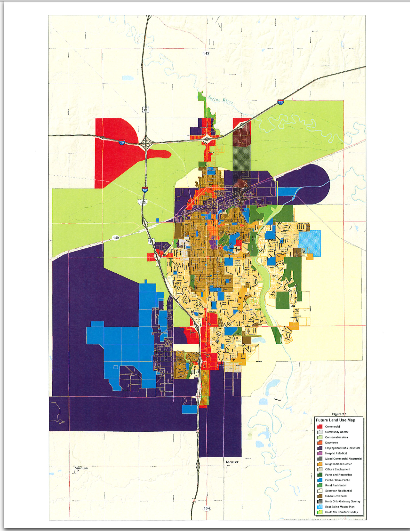
Within the Urban Service Area, the Comprehensive Plan includes a Future Land Use Map as a guide to future uses of land within the Urban Service Area and identifies various Economic Development Hubs within the community and Urban Service Area. These hubs include the Airport Industrial Center, the South 9th Street Commercial and Commercial / Industrial Corridor, Downtown and the North Downtown Area.
On Page 2-4 the Comprehensive Plan states:
The intent of the Future Land Use Map is not to predetermine land use or zoning for any one site or specific locations. The Future Land Use Map provides a land use framework for many future public and private decisions that will impact growth and development for Salina. It is a general guide that establishes relationships among various uses and intensity of development on a broad scale. Analyzing land use at this scale facilitates comprehensive and long-range planning for the city.
Future zoning map amendments should be guided by the Future Land Use Map, as well as other goals, objectives and policies of the plan. Not all zoning applications are reasonable simply because they propose zoning districts that fall within ranges of use and intensity indicated on the Future Land Use Map. If an application conflicts with other goals, objectives or policies of the plan, or does not meet the location or development criteria (as defined by the land uses in this chapter) when applied to specific sites or locations, it should not be considered reasonable. Additionally, other zoning applications beyond the ranges of land use and intensity indicated on the Future Land Use Map may be reasonable in limited circumstances where projects clearly further the intent reflected by the general guidance of the map or further other goals, objectives, and policies of the plan.
It goes on to state that where circumstances or land use and development goals have changed, amendments to the land use map may be appropriate to accommodate development that furthers the plan vision and other goals of the Comprehensive Plan. The reasonableness of any specific zoning request should be evaluated on:
- the general goals, objectives, and policies of the plan
- the Future Land Use Map
- how well specific planning for the site accomplishes the guidance provided by a specific land use category
- application of the zoning district standards and criteria for a proposed zoning district to the site, including relationships and transitions to surrounding areas
The broad categories of land use indicated on the Future Land Use Map are defined by their primary uses: those land uses that most reflect the intensity and character of the category and which are generally acceptable throughout the area; and secondary uses: those land uses that are supportive of the primary uses, and with appropriate limitations, location considerations, and development conditions can reflect the intensity and character of the category as well.
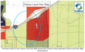
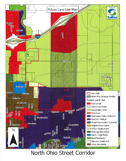
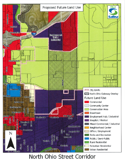
The property that is the subject of this amendment request is shown to be in a Conservation Area west of North Ohio Street and a Commercial land use area along North Ohio Street on the City's Future Land Use Map.
Conservation land use area:
'The Conservation land use category represents those areas of Salina and adjacent unincorporated Saline County in which development should not be encouraged. The conservation designation generally follows the mapped 100 year floodplain areas within and adjacent to Salina without levee protection. Development should not be encouraged for numerous reasons, most notably, to protect natural resources or environmental elements and / or because of the lack of infrastructure availability now or in the future. The extension of infrastructure including water, sewer and streets to these areas can be expensive and development will not occur in an urban form."
Primary uses allowed in a Conservation Area include agriculture, open space, recreation areas and trails. These uses are consistent with the City's Floodway Regulations.
Commercial land use area:
"Commercial land uses are currently located around Salina primarily along major transportation corridors. The commercial land use designation provides the opportunity for the development of general retail and service uses that serve neighborhoods, the community and the region."
Future development of suburban style and large scale commercial businesses that rely on traffic for their business will continue to locate in two areas, North 9th Street at Interstate 70 and South 9th Street at Magnolia Road and Schilling Road. Specialized and niche business should be encouraged to locate in the downtown area. Commercial uses that serve existing and future neighborhoods should be encouraged to develop within mixed-use centers.
Primary uses allowed under the Commercial category are:
- Retail / Service
- Office
- Civic and Institutional
Potential zoning districts are:
- C-3, C-5, C-6, C-7 and PDD
Nature of Current Request
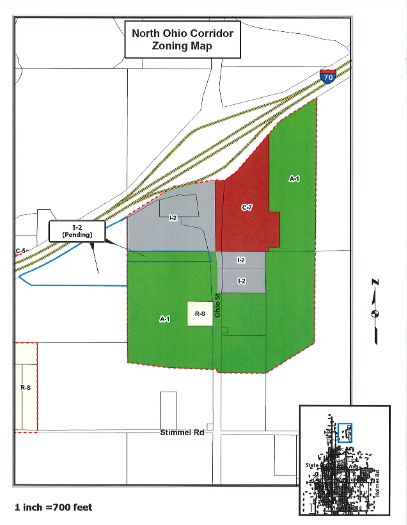
When the City Planning Commission was reviewing a request filed by Beck's Hybrid Seeds to rezone a portion of the Ward Trust property of North Ohio Street to 1-2 (Light Industrial) to allow it to become a part of their proposed corporate campus, staff informed the Commission that the portion of the North Ohio corridor south of 1-70 that was outside the existing city limits, including the Ward Trust property, was shown as being part of a Conservation area on the City's Future Land Use Map. The Conservation designation is an indication that the property is not expected to receive City utilities or be developed. As noted previously, Conservation areas are flood prone areas that are not protected by the City's flood control levee and where new development is not encouraged.
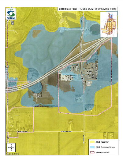
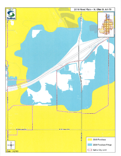
At the June 20, 2023 public hearing where the Planning Commission reviewed annexation, rezoning and platting requests submitted by Beck's Hybrid Seeds, the Planning Commission took note of the fact that Beck's engineers had demonstrated it was feasible to extend public utilities to the Ward Trust property and that a majority of the 19.80 acre proposed building site had been taken out of the mapped 100 year flood plain on the 2018 Flood Plain Map Update.
At the June 20, 2023 public hearing, the Planning Commission found that the proposed Beck's site (Ward Trust property) is located within the City's Urban Service Area and that based on the plans for this property submitted by the applicant, including the extension of public utilities to the site, Employment Area is a more appropriate Future Land Use Map designation for this area than the current Conservation Area designation. The Planning Commission voted 6-0 to recommend that the Zoning Map of the City of Salina be amended to change the zoning classification of this 23.92 acre site from Saline County AG and A-1 (Agricultural) to 1-2, as requested by the applicant, subject to satisfactory platting of the property.
Based on their finding that the current Future Land Use Map was out of step with the current conditions, at their June 20, 2023 meeting the Planning Commission also approved a motion directing staff to initiate a Future Land Use Map amendment to amend the Conservation Area boundary to show the Beck's site as an Employment Area and to look at the designation of the other property on the west side of North Ohio Street.
The Beck's rezoning application was considered on first reading at the July 10, 2023 City Commission meeting with the knowledge and understanding that the Future Land Use Map Amendment would be considered prior to final approval of the Beck's project. Final zoning and plat approval for the Beck's Addition is tentatively scheduled for September 11th so this map amendment will be considered and approved or not approved prior to final zoning approval for the Beck's site.
Planning staff prepared and filed a Comprehensive Plan Land Use Map Amendment application on behalf of the Planning Commission and August 1, 2023 was set as the hearing date to consider this potential plan amendment.
Staff Comments / Analysis
Comprehensive Plans and Future Land Use Plans are not intended to be static documents and should be reviewed periodically. The Kansas Planning and Zoning Enabling Act establishes a process for amending Comprehensive Plans in K.S.A. 12-747. The burden is on the proponent of the plan change or amendment to justify the amendment.
Some factors that the Planning Commission and City Commission should consider are:
- Whether the amendment is justified by changing conditions in the community.
- Whether the amendment advances goals and policies contained in the Plan.
- Whether there is a public need for changing the Comprehensive Plan map.
- Whether the public need is best served by changing the land use designation of the site in question as compared with other available property.
- Whether the requested change would negatively impact the surrounding area.
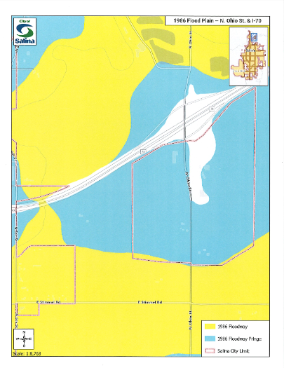
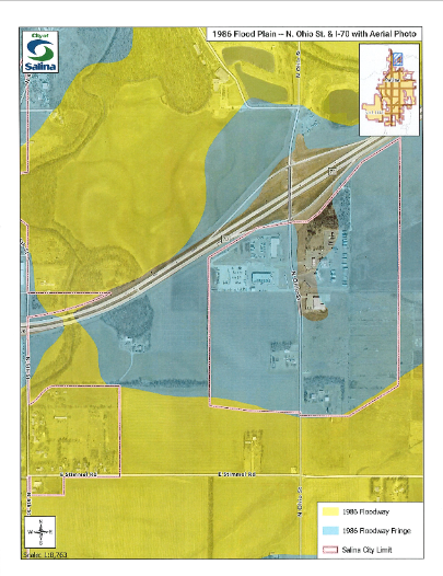
In regard to the above listed criteria, staff would offer the following comments. In 1986, the City of Salina entered the National Flood Insurance Program (NFIP) and adopted new Flood Insurance Rate Maps (FIRMS). The area between the City's flood control levee and 1-70 was designated as either being in the 100 year flood plain or the floodway for Mulberry Creek. In 1994, the Flying J travel plaza complex at Ohio Street and 1-70 was annexed into the City. In 2000, the Salina City Commission authorized the design of utility extensions that would provide water and sanitary sewer service to properties along North Ohio Street south of 1-70. A design contract was awarded to Wilson & Co. The identified properties were properties south of 1-70 that were in the mapped flood plain and not the floodway where new development is prohibited.
On December 17, 2001, Annexation Ordinance Number 01-10068 was passed on second reading. This ordinance annexed approximately one hundred sixty-four (164) acres of land along North Ohio Street into the city. This annexation involved requests from eight (8) separate property owners along the North Ohio corridor between Stimmel Road and 1-70. The purpose of these requests was to allow those properties to connect to the City's water and sanitary sewer systems upon completion of a proposed public water line and sewer line project on North Ohio Street. Annexation was required to allow connection to City utilities and to be included in the benefit district that was created to finance the utility line extensions.
As noted, the 2001 island annexation south of the North Ohio Street and 1-70 interchange was based largely on the 1986 flood maps. The southern boundary of the North Ohio Street and 1-70 interchange island annexation corresponded with the northern boundary of the floodway. Virtually all of the property between the City of Salina flood levee and the North Ohio Street and 1-70 interchange island annexation is floodway, except for the property closest to the interchange which was mapped flood plain. Additionally, 100% of the Ward property west of the existing North Ohio Street and 1-70 interchange island annexation was in the mapped flood plain when the 2010 Comprehensive Plan Future Land Use Map was adopted. However, when the flood maps were updated in 2018, much of the Beck's annexation area was removed from the flood plain.
The Planning Commission recommended that the language in the Comprehensive Plan that stated development should be "prohibited" in the Conservation Area be changed to "discouraged." The Planning Commission made the following recommendations regarding development in the Conservation Area:
Proposals to develop property located within the Conservation Area will be considered if one or more of the following criteria are met:
- Submission by the property owner of an elevation survey demonstrating that based on existing ground elevations the property is above the 100 year flood elevation and is therefore not located in a 100 year flood plain
- There are existing City utilities (water and sanitary sewer lines) in place that are capable of serving the site
- Saline County has already conferred some development rights on the property that the City of Salina must recognize. (A project that has vested development rights through County approval)
Development in the Conservation Area must conform with state and local flood plain regulations and Best Management Practices for development within flood prone areas.
In support of this application to amend the Future Land Use Map, staff would offer the following comments as justification for a plan amendment:
- The request area was previously identified as a Conservation Area because it was located entirely within the mapped 100 year flood plain in 2010. The 2018 flood map updates removed most of the request area from the mapped 100 year flood plain, which would now support it being designated in a different land use category such as Employment.
- Interstate interchanges are a finite resource for the community, particularly interchanges on 1-70, of which there are only two, North 9th Street and North Ohio Street. When the Comprehensive Plan was adopted, there was a belief that the area on North Ohio south of 1-70 should be set aside for highway oriented uses serving travelers on 1-70 such as travel plazas, convenience stores, motels and restaurants. Therefore, the Ohio Street corridor south of 1-70 was shown as future Commercial with the expectation that most of the property would be zoned C-7 (Highway Commercial). There has been very little development interest shown on North Ohio by businesses serving interstate travelers. Instead, the interest has been shown by light industrial and service businesses such as Foley Equipment Co., a utility company in the former Harley Davidson building and Beck's Hybrid Seeds. All of those businesses fit best within an 1-2 (Light Industrial) zoning classification, which does not fit with either the Commercial or Conservation land use category.
- The requested change is consistent with goal LU.1 which promotes efficient use of public infrastructure because it is located within close proximity of existing public infrastructure and public services. Public water and sanitary sewer have been extended to the Ohio Street & 1-70 interchange area, and there are natural gas and electrical lines already in place in this area. The City of Salina has also identified this as a Primary Service Area/Growth Area for the extension of City utilities and services.
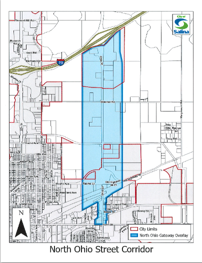
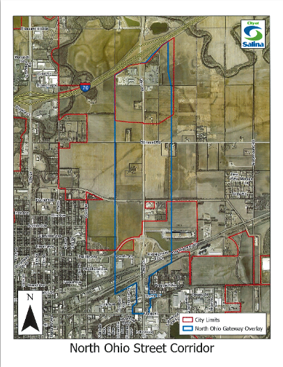
- The change would conform to goal LU.4 which encourages the development of employment hubs in the city by expanding an employment hub that exists in the North Ohio Gateway Overlay district and would facilitate large land intensive uses and jobs for the community.
- The land use change would also be consistent with goal LU.7 which encourages the protection of flood prone areas because the requested change area is no longer entirely within the flood plain, and its boundaries do not encroach into natural areas, natural resources, or flood plain that would otherwise necessitate being categorized as Conservation.
- Changing the land use to Employment is also supported by the location criteria of the Employment land use category outlined in the comprehensive plan. The proposed area of change would be located in proximity to support services with good access to a major arterial road and the interstate, is generally located away from existing or planned residential developments, and would not feed traffic onto local streets in residential areas.
- The primary reason that the proposed Beck's site was categorized as Conservation land use is that it was located entirely within the mapped 100 year flood plain (Flood Zone A5), which was consistent with the location criteria for the Conservation land use category. Now that a significant portion of the area is no longer in the flood plain, it would be in the public interest to amend the land use to a category that makes it available for development in a manner consistent with the surrounding area.
- There is currently development interest in this location that would provide an economic benefit to the community. The proposed development would be most appropriate within an 1-2 zoning district. Given that this area is adjacent to the Commercial land use area located at the North Ohio Street and 1-70 interchange and the North Ohio Gateway Overlay District, the most appropriate land use category that_v,.,ould b compatible with proposed development and the surrounding area would be the Employment land use category. (Staff would note that the previous Beck's site was located within the North Ohio Overlay district and was subject to the Overlay District development standards which include building design, paved parking and landscaping. These same standards do not apply under straight 1-2 zoning and the City Commission would have the option of extending the boundaries of the Overlay District west to include the Beck's site to insure quality industrial development at one of the gateways into the city).
- Although most of the requested area was removed from the 100 year flood plain with the 2018 updated flood maps, a portion of this area is still within the AE flood zone. Staff has determined that it would be possible to develop the site without increasing flood heights. This would be possible by elevation of any building pads to at least one (1) ft. above Base Flood Elevation (BFE) and by utilizing a remnant of the old Mulberry Creek oxbow that was cut off from the waterway by 1-70 as compensatory storage.
Planning Commission Recommendation
The role of the Planning Commission in this case was to decide what its vision is for the future development of the North Ohio Corridor and the Ward property directly to the west. The Planning Commission looked at whether the Ward property was more closely related to the North Ohio Street commercial corridor, adjacent to 1-70, therefore justifying an adjustment of the Conservation Area boundary, or more closely related to the surrounding Conservation Area (floodway) located between the City's flood control levee and 1-70.
The Planning Commission conducted a public hearing on this potential Future Land Use Map Amendment at their August 1, 2023 meeting. Following presentation of the staff report, including flood maps for the area, and comments and questions by Commission members, the Planning Commission voted 7-0 to recommend that the Future Land Use Map (Figure 2.1) in the Salina Comprehensive Plan be amended to show all of the west side of North Ohio Street, including the Ward property as future Employment instead of future Commercial and Conservation Area.
In support of its recommendation, the Planning Commission took note of the fact that the City of Salina has invested in extending public utilities to the North Ohio Corridor, that the extent of the mapped 100 year floodplain was greatly reduced on the 2019 community flood maps and that the City Commission has rezoned multiple properties in the area to 1-2 in conflict with the Commercial land use designation.
FISCAL NOTE:
There will be no direct fiscal impact on the City as a result of this land use map amendment.
The motion was approved 4-0. Mayor Hoppock recused himself.